
Among the first seafarers to use celestial navigation for wayfinding, ancient Polynesians developed stick maps. They charted over a million square miles of ocean.
While some maps refer to the sky, most chart currents and wind patterns on the water's surface. Wayfinders used shells to mark the locations of the islands.
While some maps refer to the sky, most chart currents and wind patterns on the water's surface. Wayfinders used shells to mark the locations of the islands.
Navigating with nature's guidance, travelers observed wildlife, the position of stars, and the sun and moon to chart their course.
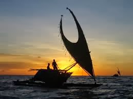
The sun, at sunrise in the East and sunset in the West, guides the navigator without instruments and provides direction.

Creative Write: How would you define wayfinding with a voyage into words? Use the sun, moon and stars for guidance.
No comments:
Post a Comment